The location and accessibility of Faisal Town Phase 2 are among its most discussed features, particularly for investors, overseas Pakistanis, and long-term buyers comparing Islamabad’s emerging residential corridors.
This page explains:
- Where Faisal Town Phase 2 is situated
- How it connects to Ring Road, M-2 Motorway, and Islamabad International Airport
- Its positioning relative to Capital Smart City and Thallian Interchange
- Why location plays a strategic role in future usability and value
📞 For verified location guidance: +92 331 1110174
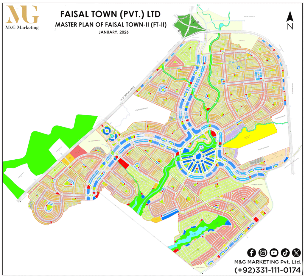
Where Is Faisal Town Phase 2 Located?
Faisal Town Phase 2 is located within the outer Islamabad development belt, positioned along routes that connect Islamabad, Rawalpindi, and major intercity infrastructure.
Its location is often evaluated in the context of:
- Ring Road connectivity
- Proximity to Islamabad International Airport
- Access toward GT Road and M-2 Motorway corridors
This positioning places it within a long-term expansion zone, rather than a central-sector development.
Faisal Town Phase 2 Location Map Overview
Buyers typically review the location through:
- Google Maps (for orientation and distance estimation)
- Access road analysis
- On-ground verification via consultants
For overseas Pakistanis, map-based evaluation combined with professional local confirmation helps avoid misinterpretation of distance or access claims.
📞 Remote location walkthrough: +92 331 1110174

Ring Road Connectivity (Key Selling Point)
One of the most important accessibility factors is Ring Road connectivity.
Ring Road plays a major role in:
- Reducing travel time between Islamabad zones
- Improving access to developing housing societies
- Enhancing long-term property usability
Projects with Ring Road access are often preferred by:
- Investors planning medium-to-long-term holding
- Buyers seeking future connectivity rather than current congestion
Proximity to Islamabad International Airport
Islamabad International Airport is a major reference point when evaluating Faisal Town Phase 2’s location.
Airport proximity matters because:
- It increases appeal for overseas Pakistanis
- It supports future commercial and residential demand
- It improves overall regional accessibility
Actual travel time may vary depending on route and traffic conditions and should always be verified.
Access to M-2 Motorway & Thallian Interchange
M-2 Motorway
The M-2 Motorway connects Islamabad to Lahore and remains a critical national artery.
Housing projects near M-2 access routes are often evaluated for:
- Intercity travel convenience
- Long-term strategic value
- Reduced dependency on inner-city routes
Thallian Interchange
The Thallian Interchange is another key access reference.
Its relevance includes:
- Improved connectivity toward airport and motorway corridors
- Enhanced movement between Islamabad’s outer developments
- Increased investor attention in surrounding zones
Location Comparison: Faisal Town Phase 2 vs Capital Smart City
When evaluating location, buyers often compare Faisal Town Phase 2 with Capital Smart City.
Common comparison points include:
- Ring Road and motorway access
- Distance from Islamabad city
- Development model and timelines
While both are positioned along expansion corridors, location suitability depends on buyer objectives, not branding alone.

Nearby Developments & Surrounding Context
Faisal Town Phase 2 is surrounded by emerging residential and infrastructure-driven developments, contributing to gradual area maturity.
This surrounding growth often supports:
- Long-term livability
- Infrastructure expansion
- Incremental demand growth
However, buyers should evaluate each development independently.
Developer Background & Location Credibility
The project is associated with:
- Chaudhry Abdul Majeed
- Zedem
Developer background is often considered by buyers when assessing:
- Planning consistency
- Execution track record
- Market confidence
Why Location Matters for Investment & Living
Location directly impacts:
- Long-term appreciation potential
- Resale liquidity
- End-user demand after possession
- Overseas buyer confidence
Projects aligned with major infrastructure corridors are usually evaluated with a long-term lens.
Location Considerations for Overseas Pakistanis
Overseas buyers should assess:
- Ring Road and airport connectivity
- Motorway access
- Distance perception vs actual usability
- On-ground verification through trusted advisors
📞 Overseas buyer support: +92 331 1110174
How M&G Marketing Helps With Location Verification
M&G Marketing Private Limited assists clients by:
- Explaining location context beyond map pins
- Verifying access routes and connectivity claims
- Comparing Faisal Town Phase 2 with nearby societies
- Supporting local and overseas buyers objectively
📞 Speak with a property consultant: +92 331 1110174
Frequently Asked Questions (Location & Accessibility)
Is Faisal Town Phase 2 connected to Ring Road?
Yes. Ring Road connectivity is a key factor in its accessibility evaluation.
How close is Faisal Town Phase 2 to Islamabad International Airport?
It is considered accessible, though actual travel time varies by route and traffic.
Does M-2 Motorway access add value to the location?
Motorway proximity is often seen as a long-term strategic advantage.
How does Faisal Town Phase 2 compare with Capital Smart City location-wise?
Both are positioned along expansion corridors; suitability depends on buyer goals.
Can overseas Pakistanis assess the location remotely?
Yes. Maps combined with professional consultation provide reliable evaluation.